Correspondence Analysis of Natural Disaster Distribution Patterns on Java Island in 2023
Keywords:
Correspondence Analysis, Natural Disasters, Java Island, Disaster Distribution, BNPBAbstract
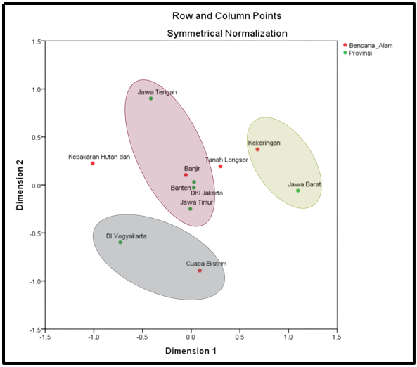
Indonesia is geographically located at the convergence of major tectonic plates and within a tropical climate zone, making it highly vulnerable to various natural disasters. Java Island, as the most densely populated region in Indonesia, experiences a significant number of disaster events each year. This study aims to analyze the distribution patterns of natural disasters across provinces on Java Island in 2023 using Correspondence Analysis. Secondary data were obtained from the Indonesian National Disaster Management Agency (BNPB) and organized into a contingency table consisting of provinces and types of natural disasters, including floods, landslides, extreme weather, droughts, and forest and land fires. The analysis involved descriptive statistics, independence testing using Pearson’s Chi-square, and correspondence analysis for dimensional reduction and visualization. The results indicate a significant association between disaster types and provincial characteristics. Floods were predominantly associated with DKI Jakarta, Banten, East Java, and Central Java, while droughts were closely related to West Java. Extreme weather events were mainly observed in the Special Region of Yogyakarta. These findings provide valuable insights for regional disaster mitigation planning and policy formulation tailored to provincial disaster characteristics.